Bradford County Conservation District
  • Home
  • About
    • Our Team
    • History
    • Careers
    • Board Meetings
    • Right to Know Request
    • BCCD Earth Day
  • Programs
    • Agriculture & Soils >
      • Woodchip Barnyard Project
      • No Till Garden
      • Interseeder
      • Farmland Preservation
      • Women in Agriculture Day
    • Dirt, Gravel & Low Volume Roads
    • Education >
      • Scholarship Opportunities
      • Envirothon
      • Conservation Field Day
    • Environmental Permitting >
      • Chapter 102
      • Chapter 105
    • Forestry >
      • Spotted Lanternfly
    • Watershed Restoration >
      • Pond & Lake Management
      • Stream Crossing Replacements
    • West Nile Virus
  • Blog
  • Events
  • Contact

Pond & Lake Management

Picture

New Regulation to Know: Notice of Stocking

Effective January 1, 2024, the Pennsylvania Fish and Boat Commission (PFBC) is requiring any person or group engaged in stocking fish into Commonwealth waters to notify the PFBC by way of Notice of Stocking (NOS).  An NOS is needed for:
  • Stocking flowing water such as rivers, streams, or creeks on public and private property.
  • Stocking non-flowing water such as lakes, ponds (including farm ponds), or reservoirs on public and private property.
Click Here for More Info
From the Pond - Newsletter
Picture
In 2007 the Bradford County Conservation District (BCCD) created the Pond and Lake Management Program in response to the increased need for pond and lake related assistance within our community.  Since then, we have worked with different state agencies to collect water quality data and also provide education and outreach opportunities for pond/lake owners within our county. The goal of this program is to inform and assist landowners through workshops, on-site visits, and available services the BCCD as to offer. 

Contact Lacy Powers for more information at 570-485-3139
Pond Management | PSU Extension
Pond & Lake Water Testing
Watercraft Inspection Handbook

Upcoming Events

Check back later for future events!

​Pond & Lake Services Available 

+Pond/Lake Management Plan Development
    - Bathymetric Mapping
    - Plant Identification
    - Management Planning

+Permitting

+Water Quality/ Plant Assessment/ On-site
  Management Suggestions

    - Determine baseline water quality readings 
        ~ Temperature, Dissolved Oxygen, Specific
​          Conductivity, pH​​
+On-site visit for discussion of physical repairs
    - Dredging
    - Dam and/or Spillway Maintenance
​
+Wetland Presence Determination/        New Pond Construction Planning
    - Provide guidance for potential               wetland impacts
    - Recommend wetland delineation 
       if needed
    - Identify adjacent watercourses
       and floodways present
    - Education on wetlands and their
​       environmental roles
​
Picture
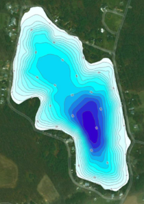
Example bathymetric map
Riparian Buffer Vegetation- Your Water Quality Protector
A riparian buffer, the vegetated area near a stream or body of water, plays a crucial role in protecting water quality.
  • Sediment Trapping- The vegetation slows down runoff and allows sediments to settle before reaching the water.
  • Nutrient and Pollution Filtration- Plants in the riparian buffer absorb and use the nutrients in runoff, such as nitrogen and phosphorus, and prevent them from entering the waterbody. Excess nutrients can lead to algal blooms and eutrophication. They also filter and breakdown pollutants such as pesticides and heavy metals that reduce water quality. 
  • Bank Stabilization- The root systems in riparian buffers help stabilize the shoreline and reduce erosion that can allow excess sediment into your waterbody and reduce its lifespan.
  • Temperature Regulation- Trees and other plants in a riparian buffer create shade which helps regulate water temperatures.  This is critical for many aquatic species that require cold water to thrive. 
  • Reduce Nuisance Wildlife- Having a riparian buffer reduces easy access to the water.  This can deter nuisance waterfowl such as geese from creating water quality issues due to increased bank erosion and excrement runoff.
It is recommended to have a minimum of 35 feet of vegetated riparian buffer around your pond to reduce water quality issues, but any amount of riparian buffer is better than none at all!

Permits and Pond Building

​Pond permitting can be a confusing process; we are here to help!
Considerations for your potential pond site:
Size of earth disturbance​​

Any project involving earth disturbance requires an implemented plan to stop accelerated erosion and sedimentation. If the earth disturbance exceeds 5,000 square feet, a written and implemented plan IS required, but may not need to be reviewed by the BCCD staff.

If earth disturbance (including all cuts and fills measured to the outside toe of the dam slope, plus any associated access roads, parking areas and pavilions, etc.), exceeds 1 acre, a National Pollutant Discharge Elimination System (NPDES) permit IS required for your project. This permit needs engineering approval and would be reviewed by the Bradford County Conservation District staff.

​The easiest solution is to keep your combined disturbance under 1 acre! 
Physical characteristics of pond
​

A dam permit from the PA Department of Environmental Protection (DEP) will be required when ponds trigger size limitations. However, as long as certain criteria are met, a dam permit would not be required:

If the pond is on a stream, and one of the following three criteria is met, then a dam permit would be required from DEP.
​

1) Upstream drainage area exceeds 100 acres.
2) Dam height above the existing ground elevation at the inside toe exceeds 15’.
3) Dam storage capacity (pond surface area x average depth) exceeds 50 acre-feet.

A pond NOT built on a stream would require a dam permit IF criteria 2 AND 3 are met.
Wetland Presence

​Often, people want to build ponds in wet areas, but frequently these areas are classified as wetlands. However, wetlands are valuable natural resources which are protected at the federal (US Army Corps of Engineers) and state (DEP) levels.

Wetland presence is determined by: 
Vegetation
Soils
Hydrology

More information on how wetland presence is determined can be found here: Wetland Delineation Methodology & Technical Criteria

Cutting and/or filling wetlands requires state and/or federal permits and may result in fines and other enforcement action.
Note: An Environmental Assessment is required from DEP if the pond is located in, along, or projecting into a wetland or across a stream, or if the pond will be located in an Exceptional Value watershed. Any excavation of streams, wetlands, or floodway within the impoundment area would require an encroachment permit from DEP. Official determinations related to potential dam, encroachment (joint), maintenance dredging and other possible permits (such as a GP-4) must be made by DEP and the Army Corps of Engineers.
Ponds- Planning, Design, and Construction Handbook
Bradford County Conservation District
​​
​Stoll Natural Resource Center
200 Lake Road, Suite E | Towanda PA 18848
Phone: (570)-485-3144
Programs
Agriculture and Soils
Dirt Gravel & Low Volume Roads
Education
Forestry

Chapter 102
Chapter 105
Watershed Restoration
West Nile Virus
Quick Links
Programs Resources
Blog
Events Calendar
Get Assistance
  • Home
  • About
    • Our Team
    • History
    • Careers
    • Board Meetings
    • Right to Know Request
    • BCCD Earth Day
  • Programs
    • Agriculture & Soils >
      • Woodchip Barnyard Project
      • No Till Garden
      • Interseeder
      • Farmland Preservation
      • Women in Agriculture Day
    • Dirt, Gravel & Low Volume Roads
    • Education >
      • Scholarship Opportunities
      • Envirothon
      • Conservation Field Day
    • Environmental Permitting >
      • Chapter 102
      • Chapter 105
    • Forestry >
      • Spotted Lanternfly
    • Watershed Restoration >
      • Pond & Lake Management
      • Stream Crossing Replacements
    • West Nile Virus
  • Blog
  • Events
  • Contact