CONSERVATION CORNER
A weekly blog for all things conservation
 By: Andy Yencha; Penn State Extension
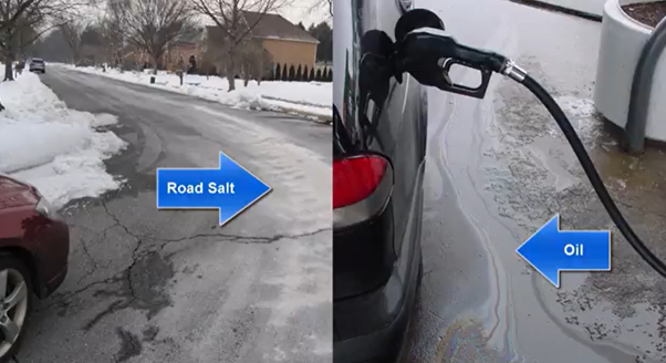
Stormwater harms local creeks, rivers, and lakes in two major ways. It causes physical damage like flooding, streambank erosion and loss of fish habitat when too much water drains into a creek or river too quickly; and it causes water pollution because stormwater often contains harmful materials picked up when it washed across the land. These pollutants can be grouped into five broad categories.
0 Comments
 By: Jennifer R Fetter; Penn State Extension
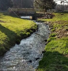
Having a stream in your yard can be a beautiful addition to your property. It can also be a source of frustration and confusion when things aren't going well. Winter weather and heavy rains this spring my have taken a toll on your backyard stream this year. Or maybe your stream has been slowly eroding for many years. The stream might be getting deeper and deeper. The banks might be caving in, taking your valuable property for a ride downstream. Maybe your foot bridge or fence is about to fall in the stream too. By: Jennifer R Fetter; Penn State Extension Floods are a nuisance. Whether in the streets, parking lots, or your own front yard – they are no fun. Have you ever wondered why your community floods more now than it used to? Beyond being a nuisance, floods have a significant impact in our communities. Floods cause loss of life as well as damage to buildings and other structures. In 2017 alone, Pennsylvanians suffered nearly $7 million worth of property damage and two people lost their lives as a result of flooding.1 What exactly happens during a rain storm that would lead to a flood? It starts with understanding what options rain water has when it hits the ground. In a forest, up to fifteen inches of rain per hour can be absorbed into the soils – becoming groundwater that fills our aquifers and also provides water for trees and other plants to grow. In our developed communities, most of that rain water becomes runoff instead. There are very few places left for water to soak into the ground, so it rolls downhill off of our rooftops, over streets and sidewalks, until it reaches a low point like a stream or river. 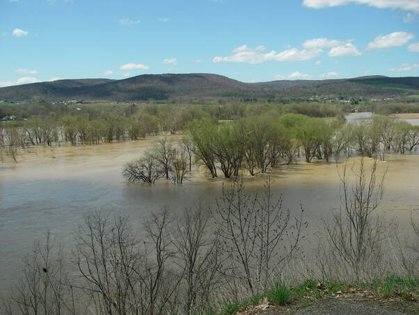 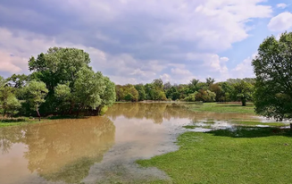 By: Susan Boser; Penn State Extension
In Pennsylvania, we get an average of 41 inches of precipitation each year. When it rains or the snow melts, where does this water go? In more natural areas, water is quickly able to infiltrate into the ground. A forested area allows for about 18 inches per hour of infiltration, where an average lawn allows for about 2 inches per hour. Impervious surfaces like pavement and rooftops, offer no infiltration at all. All of the water that doesn't infiltrate flows over the ground, over roofs and through gutters on buildings, into storm drains, and into the nearest waterway –our lakes, rivers, and streams. This is stormwater. 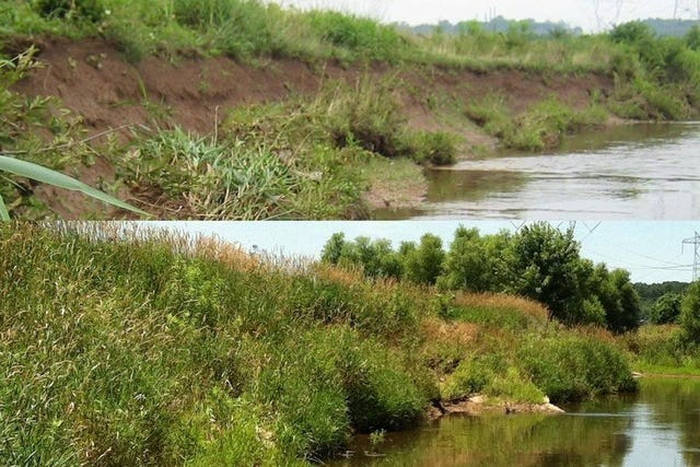 By: Sarah K. Xenophon, Kristen Koch, and Jennifer R Fetter; Penn State Extension
One of the many visual indicators you might use to assess the health of a stream is the amount of stream bank vegetation and other cover. You might find yourself walking along a stream or river, either on your property or when visiting a park or your local woods, and wish you had an easy way to understand the health of that stream. One indicator of stream health is the condition of the stream bank cover. When we talk about stream bank cover, or simply bank cover, we are talking about how much of the soil immediately adjacent to the water is covered by growing vegetation, stable debris, or bedrock material. This helps determine the health of a stream because it can tell us a lot about the relative stability of that stream. A stable stream maintains the same shape and flow pattern over time. A healthy, stable stream typically has more bank cover than an unhealthy stream. Bank cover helps reduce erosion by reducing the amount of soil exposed to passing water as it rushes into and down the stream. The stability of a stream is vital for any organisms that live in and around the stream and for protecting your property and nearby infrastructure (driveways, sewer lines, bridges, and more). By: Joe Quatrini; Technical Team Leader; BCCD Have you ever seen something that was different than what you’re used to and thought “Hmm, that’s different it must be BAD!” Maybe you’re not even sure what you’re looking at but you decide you should hate it, just because it’s a change or you don’t understand it. Unfortunately, it’s almost what our brains are trained to do these days, especially in today’s society. We see something and judge it before we even try to figure out what it is. We often see this when it comes to projects we’re part of. 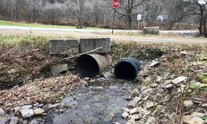 Inlet: Example of a poorly constructed stream crossing: multiple pipes and much too narrow for the stream width. Inlet: Example of a poorly constructed stream crossing: multiple pipes and much too narrow for the stream width. Take for example one initiative we are working on to help our municipalities and private landowners reduce flooding and prevent costly damage when storms hit. This initiative has to do with making stream crossings bigger. “What’s a stream crossing?” you ask. Great question and thanks for asking! A stream crossing is where a road (or a driveway) and a stream (creek, brook, run, river, etc.) intersect or cross one another. If you drive on a road and look out the window and see a stream coming right at the road and you don’t get wet, that probably means that stream is flowing through some type of pipe or bridge under the road. Obvious, right?
By: Kristin Pepper, Dirt & Gravel Road Specialist, BCCD Bradford County Conservation District (BCCD) participates in the state-wide Dirt, Gravel, and Low Volume Road Program (DGLVR) which provides funding for environmental improvements and reduced long-term maintenance of our network of dirt and gravel roads. Since its formation in 1997, the program has helped Bradford County municipalities improve approximately 73 miles of dirt and gravel roads. Each year BCCD recognizes a handful of those municipalities that stand out above the rest in various categories. This year’s Outstanding Project of the Year, also known as Golden Shovel Award, goes to (drum roll, please…) Warren Township for an exceptional overall project on Reagan Hill Road! The road crew, office staff, and supervisors all have a can-do attitude, are easy to work with, work quickly and consistently, and take great pride in their work! The project was 2,800 feet in length and consisted of adding six cross pipes to reduce the volume of water in ditches which in turn reduces erosion and sediment reaching the stream; replacing one cross pipe, adding an access pipe; added approximately 3,400 tons of road fill to promote sheet flow and gain road width; installed 700’ of drain tile to maintain a dry road surface and prevent pot-holing; installed head walls and end walls on each pipe along with rock inlet and outlet protection to reduce erosion; crowned the road surface to keep water from concentrating on the road; created stable vegetated ditches to reduce scour and filter sediments and nutrients; installed 2,200 feet of Flexamat; replaced two undersized stream crossings; and worked with landowners to accomplish this project. By installing all the above-mentioned practices, road maintenance is greatly reduced, the road is more easily traveled by vehicles, and it’s better for the environment. Thanks to Warren Township for all their hard work and dedication to their roads and all they do to improve the DGLVR Program, the environment, and the community. 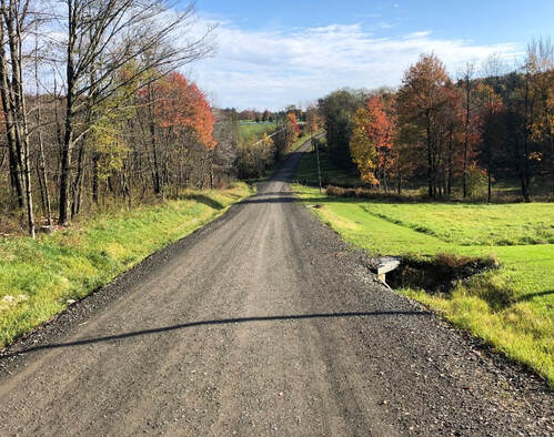  By: Pennsylvania Department of Environmental Protection
Pennsylvania’s Commonwealth boundaries encompass at least 85,568 miles of streams and 242 major publicly accessible lakes comprising 125,119 surface water acres. Section 303 of the Federal Clean Water Act requires that states, territories, and authorized tribes, collectively referred to in the act as "states," prepare water quality standards and assess all streams and lakes. Since1972 enactment, each water body is to have calculated an upper pollution limit that maintains water quality meeting state standards for each pollutant present. Standards vary among the states depending on each state’s protected uses. In Pennsylvania, these protected uses are listed as fish consumption, recreation, public water use, and biological life.  By: Tori Bristol, Dirt Gravel & Low Volume Roads Specialist
As we all know, clean water is vital for maintaining healthy aquatic habitats. As areas start to become more developed, the impacts can be seen on the water quality of freshwater ecosystems. There are many ways to evaluate the health of our streams through chemical, physical and biological assessments. One of the easiest ways that scientists (or even you at home) can judge the health of a stream is to collect Benthic Macroinvertebrates, aka Macros. |
AuthorsVarious staff at the Bradford County Conservation District Archives
April 2024
Categories
All
|
|
Bradford County Conservation District
Stoll Natural Resource Center 200 Lake Road, Suite E | Towanda PA 18848 Phone: (570)-485-3144 |
Find Us on Social Media!
|
 RSS Feed